
Our Newest Catchment Area Algorithm: Fair Supervisory Areas
You end up working with a lot of hand-drawn maps in public health campaigns. Sometimes whole planning teams rely on a piece of paper tacked to a district health office wall. These maps will often show different colored zones with careful hand-drawn markings, which tells each worker where to go during the upcoming mass drug administration campaign.
The detail can be impressive. But teams can spend weeks sketching out these boundaries, calculating populations, and trying to balance workloads fairly across supervisors. We just launched Fair Supervisory Areas in the Crosscut App to automate this entire workflow.
From districts to doorsteps
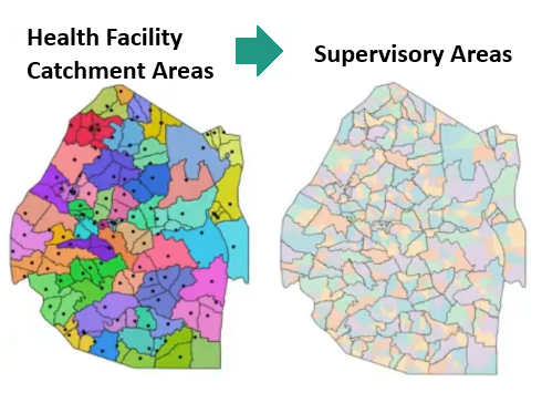
These health campaigns typically work through a clear hierarchy. One common structure includes districts that are divided into health facility catchment areas, which then break down into supervisory areas, and finally into individual community drug distributor (CDD) territories.
Each level needs to balance population, geography, and workload constraints.

The challenge is creating these nested boundaries in a way that makes sense operationally. A supervisor might oversee eight CDDs, but those workers need territories they can actually cover given the local terrain, population density, and travel conditions. Getting this balance right takes time, planning, and constant adjustments.
The old way: Paper, pencil, and best guesses
The manual mapping approach involved looking at lists of target communities and grouping them together based on a team’s understanding of the geography and population sizes. You would cross-reference whatever maps and population estimates you had available, trying to balance workloads fairly across the hierarchy.
But many times these maps don't include those details. Even when they do, the process takes weeks of manually cross-checking the data. This can lead to several problems:
- Unbalanced workloads – supervisors get overwhelmed while others under-utilized
- Changes require starting the whole process over
- No way to quickly test different organizational scenarios
- Hand-drawn maps that are difficult to reproduce or share with other teams
All those marked up maps on office walls (and spreadsheets getting emailed back and forth to track everything) represent real work and invaluable local knowledge you won't find anywhere else, but they don't hold up well to change. A supervisor leaves, a new road gets built, or population numbers shift, and teams end up starting over.
Out with the old, in with the new
Until recently, you couldn’t automatically create these balanced territories with the Crosscut App. You could upload points and get catchments around them, or ask the tool to identify settlements and draw catchments around those. But there was no way to take an administrative unit and carve it up into smaller operational units that split reasonable workloads for your team.
Fair Supervisory Areas change this entirely. This new feature automates the manual territory planning and workload balancing.
How Crosscut’s Fair Supervisory Areas work
You start by setting up your basic ratios. What's your target ratio of supervisors to community drug distributors (CDDs)? Usually it's around 1 to 8 for these MDA campaigns. How many people should each community worker serve? Can one CDD cover 300 people over the course of a campaign, or is it closer to 250 or 400? These ratios give the algorithm its constraints.
The algorithm then takes any administrative unit, district, health facility catchment area, or ward, and divides it based on these constraints. Since CDDs are the ones going door-to-door to deliver services, the algorithm factors in what actually affects their work: population density, geographic barriers, travel time, and workload balance.
⥅ Adjusting for real-world conditions
The algorithm can vary these ratios based on whether the area is urban or rural and how far it is from the health facility. In rural areas where communities are spread out, supervisors usually end up spending more time en route to locations. With more ground to cover every day, you might decide they can only manage six community workers instead of eight.
⥅ The math behind the algorithm
Once you've set those ratios, the algorithm divides up your administrative unit. It takes the population total and divides it by your target population per CDD (that 250-400 number you set) to get workers needed. Then it divides workers needed by your supervisor ratio to get supervisors needed. These calculations tell the algorithm how to automatically create balanced, manageable supervisory areas from your larger catchments.
Quick example:
- 10,000 people ÷ 300 per worker = 33 workers needed
- 33 workers ÷ 8 per supervisor = 4 supervisors needed
⥅ Working with budget constraints
This new feature also offers a constrained calculation when you're working with a fixed budget. Say you know you can only hire 50 supervisors and 400 CDDs, no matter what the ideal calculation suggests. The algorithm takes that pool of staff and figures out how to distribute them across the geographic areas as fairly as possible, making sure everyone gets a manageable workload even with limited resources.
⇾ The final fair supervisory areas
The output is a set of balanced, contiguous supervisory areas. Results also respect logical geographic barriers like rivers, roads, and administrative boundaries for more practical planning. Those hand-drawn boundaries you started with are now precise digital territories that your teams can easily share, update, and reproduce for future campaigns.
Supervisory areas are universal
This territory challenge shows up everywhere people need to make the most of limited resources. Logistics teams face the same problem when they need to divide regions into driver routes. Sales managers deal with it when assigning territories to representatives. Emergency services encounter it when organizing response zones.
Consider a delivery company expanding into a new region where they don't know the local traffic patterns or which areas will generate the most deliveries. They need to balance driver workloads while accounting for delivery density, road quality, and travel times between stops. What used to require weeks of trial-and-error route planning now happens automatically.
What this means for your planning
Those hand-drawn maps and spreadsheets with territory assignments get replaced by digital boundaries. These boundaries integrate directly into your existing systems and can be easily updated when conditions change. That means the manual process of dividing areas and balancing workloads can now happen automatically.
The supervisory areas feature works for any administrative planning challenge where you need to divide larger areas into balanced operational units. You provide the administrative boundaries and service points, and it handles the territory creation without requiring GIS expertise.
Fair Supervisory Areas are now available now in the Crosscut App, which is free for all users. For more complex territory planning needs, our advisory services design enterprise-grade GIS mapping solutions to match your specific operational requirements.
Related Posts

DHIS2 Annual Conference 2026
.JPG)

How to create catchment area maps in DHIS2 with the Crosscut App

How the Crosscut App helps plan health campaigns in Nigeria

