
Two-Tiered Catchments: Creating Territories Within Territories

"Can I create service territories within my existing service territories?" We heard variations of that question fairly constantly from teams using the Crosscut App. Teams needed to divide larger catchment areas into smaller operational units while keeping everything perfectly aligned. We took that input and created two-tiered catchments.
The partitioning problem
Territory planning requires precision and efficiency, but splitting areas into nested operational units creates coordination headaches. The partitioning challenge appears constantly across health programs.
- A district health office creates facility catchment areas, then needs mobile team zones within those catchments.
- A malaria prevention campaign maps out coverage districts, then needs community health worker territories inside each district.
- Mass drug administration programs establish supervisory regions, then need community drug distributor areas within those regions.
Until now, creating these nested structures meant running separate geospatial mapping exercises and manually verifying that boundaries matched up. You'd generate your first level of territories, export the results, then finagle a way to use those as constraints for your second level. Alignment was hit-or-miss, and changes meant starting over.
The Crosscut App now supports two-tiered catchments, meaning your previous catchment projects are now available as boundary options when you create new mapping jobs.
How nested territories work
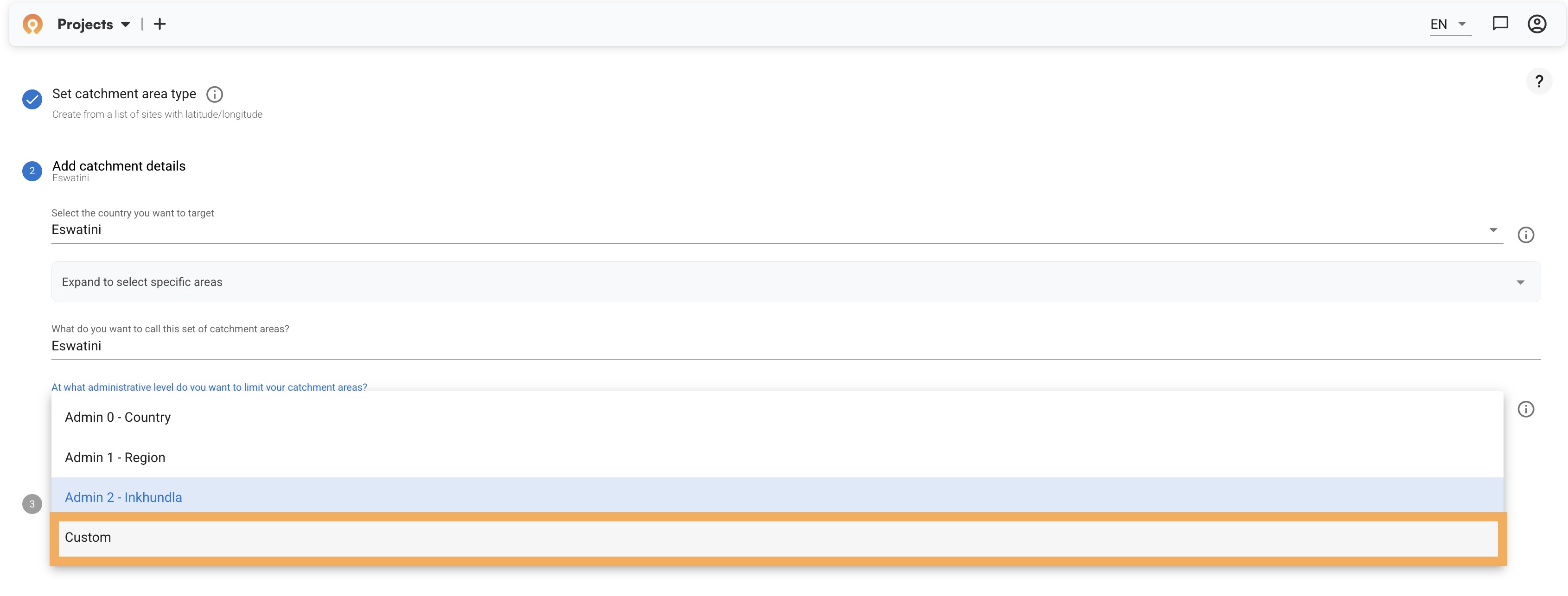
The breakthrough appears in a simple dropdown change, but with a lot of changes going on under the hood. Before we launched this new algorithm, when you set up catchment mapping, you could only constrain territories to administrative boundaries – country, region, or district level depending on your needs.
With this new addition, when you select "Custom" from the administrative level dropdown, a new field appears that lets you select a parent catchment map. Your previous catchment projects populate there, ready to serve as boundaries for new territories.
Walk through the new two-tier workflow
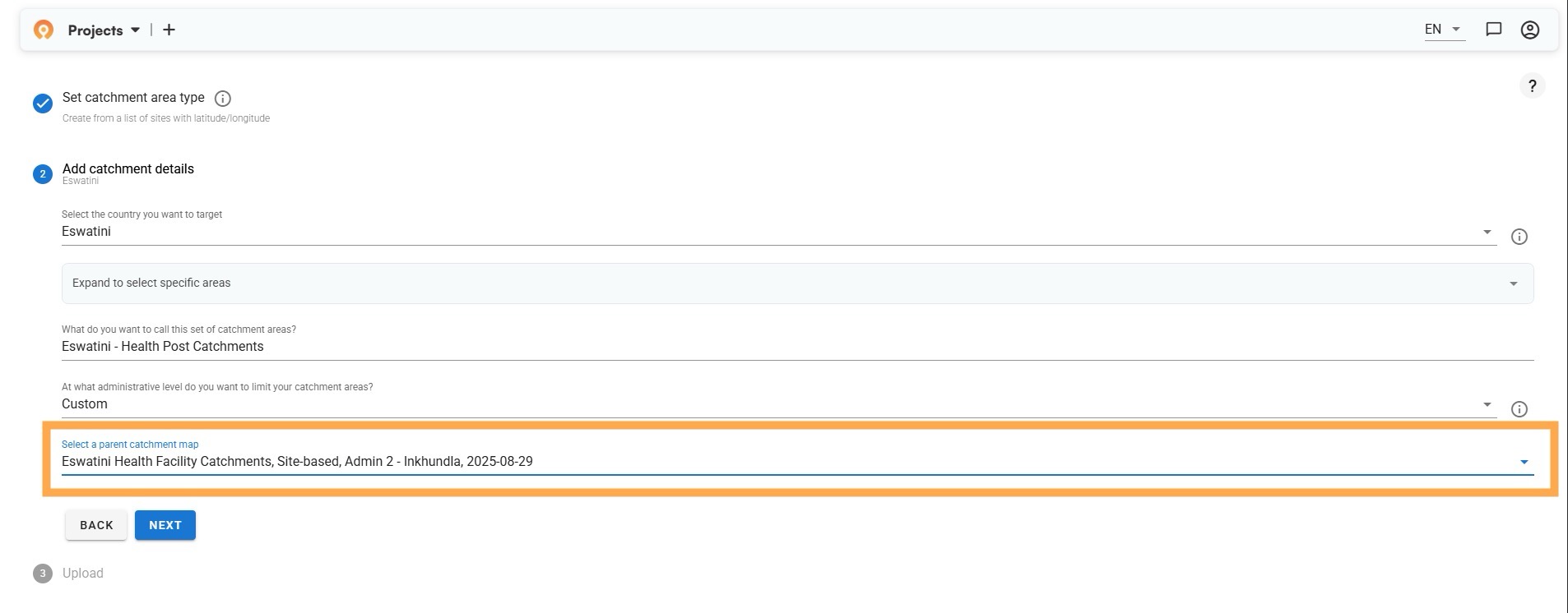
Let's walk through this workflow using a quick example. We started by creating site-based catchments around health facilities in Eswatini, but you could also opt to use the settlement-based or the newer fair supervisory areas algorithm.
After we completed that job, we started a new project for health post catchments within those facility areas. When you reach the administrative level selection, choose "Custom" (as shown above) instead of a country or district boundary.
The orange-highlighted dropdown now shows your previous project: "Eswatini Health Facility Catchments, Site-based, Admin 2 - Inkhundla." After you select it as your parent boundary, the app generates your second-level territories that stay within your first-level catchments. There’s no more manual checking or calculating needed to figure out what went wrong.
Basically, your completed catchment projects now become building blocks for more complex territorial structures. Each new job can use any previous project as its boundary constraint, letting you layer different mapping strategies to match how your programs actually operate.
Mixing and matching approaches
We also made sure this new feature is algorithmically agnostic. You can use any catchment algorithm within any previous catchment results. In our Eswatini example, we used site-based mapping for the facility catchments. But for the second level, you might choose settlement-based mapping to identify natural community clusters within each facility's coverage area, or fair supervisory areas to balance workloads across supervisors.
The big change is your first catchments become eligible in the dropdown list for your next mapping job, letting you layer different strategies rather than being limited to country or district borders. Settlement-based regions can contain site-based mobile team zones. Site-based facility areas can contain settlement-based community health worker territories.
Real-world applications
District health offices face these alignment challenges all the time. A ministry office needs facility catchment areas based on population access and travel times. And field supervisors may need territories within those catchments that account for community health worker capacity and supervision logistics.
Mass drug administration campaigns run into similar coordination challenges. You need catchment areas that account for population density and administrative coordination. Individual community drug distributors need territories within those catchment areas based on walking accessibility and treatment capacity. We now automate all the manual planning that went into these tasks.
Beyond health, the same pattern can work for any sector needing hierarchical planning. Retail chains create regional coverage areas, then need district manager territories within those regions. School systems map enrollment zones, then need bus route areas within those zones. Use cases are not restricted to one sector.
Organizational structures made simple
The real power shows up when you need multiple levels working together. Instead of coordinating separate mapping exercises and hoping boundaries align, you can build hierarchies that automatically maintain their relationships.
Take complex immunization campaigns. You might start with district coordination areas, then create facility catchments within those districts, followed by mobile team zones within each facility area. Every level stays perfectly nested, and when you update one level, the relationships hold.
The same logic works whether you're planning malaria prevention districts with spray team territories inside them, or organizing any multi-level operation where geography matters. Each level maintains its data integrity – population estimates, building counts, accessibility metrics all flow through the hierarchy without manual coordination.
What used to require weeks of boundary checking now happens automatically. The administrative overhead disappears, and gives you more time to focus on the actual planning decisions that matter.
Start nested territories today
Two-tiered catchments are available now in the Crosscut App and remain free for all users. Generate your first level using site-based, settlement-based, or fair supervisory areas and then you can easily choose your first catchment project as the parent boundary.
This addresses one of the most common challenges in health territory planning: creating nested structures that align properly. Almost any team managing complex health operations now has digital infrastructure that matches their operational needs.
I've been working with several teams on these nested structures, and automating their boundary alignment saves them a good chunk of time. If you're dealing with complex supervision hierarchies, I'd be curious to hear how you're handling it now – and how we can help.
Try two-tiered catchments (always free) or reach out to discuss how nested territories might work for your operations.
Related Posts

DHIS2 Annual Conference 2026
.JPG)

How to create catchment area maps in DHIS2 with the Crosscut App

How the Crosscut App helps plan health campaigns in Nigeria

