
Microplanning guides for health campaigns: A program-by-program reference

The success of a health campaign hinges on which communities you reach, and which you miss. Calculating that data takes organizing information about a population down to the local level, deciding who covers each neighborhood, and how supplies get there. That work is called geospatial microplanning. At its core, microplanning is a mapping exercise.
Geospatial microplanning is a powerful tool, but it can be challenging to implement. Fortunately, organizations like the World Health Organization (WHO) and the Alliance for Malaria Prevention (AMP) have produced guidance documents, with different documents addressing the different nuances and challenges that face different types of campaigns. For each, I walk through what it says about catchment area mapping, and how the Crosscut App helps you build those maps.
What is geospatial microplanning?
The microplanning workflow turns a broad target into a plan a health team can carry out village by village, or street by street. Let’s say your team needs to treat every child under five in a specific district. A geospatial microplan does four things to organize the process:
- Counts the people in a certain area.
- Divides the ground into service areas, the catchment areas each team or site covers.
- Assigns people, vaccines, drugs, or nets to those areas.
- Checks coverage to show which communities the plan reaches and which are at risk of being missed.
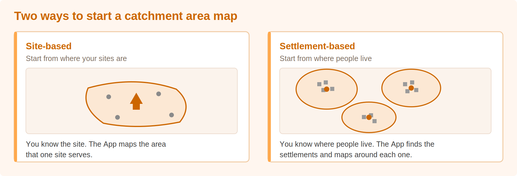
Campaign success depends on how you carve up the ground. The catchment boundary is the line around the area one facility or team covers. Draw that line in the right place and the population counts and team assignments come out right. Draw it wrong and everything after it is off. That is why these microplanning guides below spend so much time on the mapping process.
Immunization microplanning guides
Immunization happens in a few different ways, and each has its own guide. A campaign is a short, intensive push to vaccinate a target group quickly, like a measles and rubella drive. Routine immunization is the regular, year-round service run through clinics and outreach visits.
Immunization campaigns
Planning and Implementing High-Quality Supplementary Immunization Activities for Injectable Vaccines (WHO, 2016). [FILE]
- What the guidance asks for. WHO suggests running a time-bound campaign and reaching a target group across a whole district or country in a matter of days. That means estimating the target population, working out vaccine and supply quantities, and deploying and supervising the teams that deliver it.
- What it says about mapping. The guide names a map of vaccination posts in the catchment area as a core planning input, alongside non-vaccination risk factors and cold-chain capacity. It tells you to start from the operational maps of health-facility catchment areas already used for routine immunization, then build the campaign's own microplans and maps on top of them.
- How the Crosscut App finds your coverage gaps. Drop your vaccination posts onto the health-facility catchment area maps as points of interest, add a travel-time view, and the communities that will struggle to reach a post stand out. The App holds both levels at once with two-tier catchments, the health area on top and the vaccination sites inside it.
Routine immunization services
Microplanning for Immunization Service Delivery Using the Reaching Every District (RED) Strategy (WHO, 2009). [FILE] Immunization in Practice: A Guide for Health Workers (WHO, 2025 edition). [FILE]
- What the guidance asks for. Keep the year-round service reaching everyone due for those services, from infants to pregnant women, and plan it health facility by health facility. RED sets out the steps, and Immunization in Practice is the wider field manual behind it, covering the cold chain, safe injection, and running a session.
- What it says about mapping. RED's Step 2 is preparing and reviewing an operational map of your catchment area. Draw the area each health facility serves, list every village in it with its target population, and use the map to decide whether each community is reached by a fixed clinic, an outreach visit, or a mobile team. The guide says the map can be simple and hand-drawn, but its whole purpose is to make sure no group of people is left off it.
- How the Crosscut App draws your catchment area maps. If you have your facility coordinates, Crosscut maps the area each health facility serves without you hand-drawing anything. For the villages a facility cannot reach, settlement-based maps show which communities to fold into outreach and mobile sessions.
Polio microplanning guide
Best Practices in Microplanning for Polio Eradication (WHO, 2018). [FILE] Standard Operating Procedures for Responding to a Poliovirus Event or Outbreak (Global Polio Eradication Initiative, version 5.0, 2026). [FILE]
- What the guidance asks for. Reach every child in a house-to-house campaign so no one is missed. The Best Practices guide covers the campaign microplan, and the Standard Operating Procedures cover the fast planning once an outbreak is confirmed.
- What it says about mapping. Every team gets its own operational map, built from a team movement plan, showing exactly where it works each day, with team areas shaded by day and the limits of each team's catchment area drawn in. The maps are expected to show catchment areas and the location of posts, teams, and supervisors, and the readiness checklist fails a plan whose maps do not.
- How the Crosscut App finds the settlements you're missing. The App reads contiguous populated areas as settlements, so no hamlet drops off the map, then groups them into balanced team areas. Spotting the communities a campaign is about to miss is the whole point, and a catchment area map shows that far better than a list.
Malaria microplanning guides
There are two main ways to control the mosquitoes that spread malaria, and each has its own guide. One is handing out treated bed nets. The other is spraying insecticide on the inside walls of houses.
Net campaigns for malaria
AMP Toolkit 2.0 (Alliance for Malaria Prevention, 2012). [FILE]
- What the guidance asks for. The Alliance for Malaria Prevention runs a net campaign from the region down to the district and the health area, so a whole population gets long-lasting insecticide-treated nets in their homes.
- What it says about mapping. The toolkit calls household registration the key to the entire campaign, and says micro-planning and mapping have to come first, so the number of volunteers and days is enough to reach all areas and all households. The registration map, drawn per health-facility catchment area, sets how many teams each area needs.
- How the Crosscut App covers every household. Registration has to reach everyone, so rather than starting from a site list, the App reads where people live and builds settlement-based catchment areas around each population center, sizing every health area before teams go door to door.
- Ready-to-use templates. Alongside the toolkit, the Alliance for Malaria Prevention publishes microplanning guidelines that come with ready-to-use templates from real net campaigns. We have bundled them so you can start from a real example instead of a blank page. Download the AMP microplanning templates for Burundi, the Central African Republic, Ghana, Mozambique, and Uganda, plus a Sierra Leone warehouse assessment tool.
Indoor residual spraying for malaria
Operational Manual on Indoor Residual Spraying (WHO, 2024). [FILE]
- What the guidance asks for. Spray insecticide inside houses to control not only malaria but also the vectors behind Aedes-borne diseases, Chagas disease, leishmaniasis, and lymphatic filariasis, then plan and supervise the spray rounds.
- What it says about mapping. Planning starts with geographical reconnaissance, which the manual defines as mapping the distribution of the population, household locations, and other features before spraying. Teams mark the houses to be sprayed and their access routes on a sketch map, and pick sites for field camps from it.
- How the Crosscut App sizes your spray areas. A spray team's workload is the number of houses, so the App can split the ground into areas of even building count with building-based catchments, then layer travel time on top to show which areas are hardest to reach.
Neglected tropical disease (NTD) microplanning guide
Microplanning Manual to Guide Implementation of Preventive Chemotherapy (WHO and PAHO). [FILE]
- What the guidance asks for. WHO and PAHO plan mass drug administration at the level of the supervisory area, the smallest unit that delivers treatment, with several nested inside a larger implementation unit.
- What it says about mapping. Step 1 of building a supervisory area is to prepare an operational map. The manual asks you to line those boundaries up with health-facility catchment areas where you can, follow roads and rivers where you can't, and collate the areas so they reach full geographical coverage without overlapping one another.
- How the Crosscut App builds your supervisory areas. Fair supervisory areas divide an implementation unit into balanced territories that stay contiguous and do not overlap, and because they can sit inside your health-facility catchments, they hold the full-coverage rule the manual asks for. We map them this way for programs like onchocerciasis and schistosomiasis.
Cross-program geospatial microplanning guidance
Geo-Enabled Microplanning Handbook (WHO-UNICEF COVAX GIS Working Group, built on GRID3 data). [FILE]
- What the guidance asks for. The COVAX GIS Working Group built this handbook to make geospatial data the microplan itself, rather than one input among many. It is not tied to a single disease, so read it for the microplanning method overall.
- What it says about mapping. The guide says an actionable geo-enabled microplan draws on population distribution, health-facility locations, settlements, and travel time to define catchment area maps. It is blunt about what hand-drawn maps get wrong. Disjointed borders and catchment areas lead to overlaps and gaps in coverage, and missing settlements create chronically underserved areas and zero-dose children.
- How the Crosscut App puts the method to work. The handbook describes the approach, and the Crosscut App fits your data to a catchment mapping solution, with whichever mapping method fits the campaign in front of you.
Every health program comes back to the catchment maps
The diseases differ, but the underlying catchment mapping task is the same. You work out who lives where, which team can reach them, and which communities the plan leaves out. Every guide here answers those questions with specific guidance on how to map your campaign.
Table: Microplanning guides at a glance
The Crosscut App is free to use and you can generate any of these maps yourself. You can also share your projects with your team, and continue working the Excel to email workflows you already know. Reach out to us to talk over mapping solutions for your upcoming campaign.
Related reading
- What is a catchment area? https://www.crosscut.io/post/what-is-a-catchment-area-gis-tools
- Customizing Senegal's microplanning template https://www.crosscut.io/post/customizing-senegals-microplanning-template
- Creating supervisory areas in Guinea-Bissau https://www.crosscut.io/post/creating-supervisory-areas-in-guinea-bissau
- Catchment areas within catchment areas https://www.crosscut.io/post/how-to-create-catchment-areas-within-catchment-areas
Related Posts
What WHO's routine immunization guide says about catchment area maps

What the AMP toolkit says about catchment area maps for ITN distribution campaigns
What WHO's immunization campaign guide says about catchment area maps
